Iran’s Islands and the Strategic Architecture of the Strait of Hormuz: militarised geography, the role of the IRGC Navy, maritime interdiction and the logic of blockades
Analysis: MARITIME SECURITY FORUM
In analysing the Iranian defence system, the islands in the Persian Gulf and in the vicinity of the Strait of Hormuz should not be treated as mere geographical accidents, nor as peripheral points of territorial sovereignty, but as structural elements of a deliberate strategic architecture, built for surveillance, maritime interdiction, economic coercion, military resilience and political-strategic deterrence. Their importance is far greater than their physical size would suggest, as their value derives from their position relative to one of the world’s most sensitive maritime chokepoints. The Associated Press recently highlighted that islands such as Qeshm, Abu Musa, Greater Tunb, Lesser Tunb and Kharg have disproportionate importance precisely because of the combination of strategic location, military infrastructure and, in some cases, a crucial energy role.
The Strait of Hormuz is the ideal arena for an asymmetric defensive and coercive doctrine. It is not a vast expanse of ocean, where the technological and numerical superiority of a major naval power could easily translate into stable and unchallenged control, but a narrow corridor with predictable trade routes, extraordinary energy density and a geography that favours the coastal actor capable of combining surveillance, proximity and distributed threat. The Middle East Institute study shows that, although the navigation channels in the Strait of Hormuz itself lie within Omani waters, the channels and separation zones immediately inside the Gulf pass through Iranian territorial waters and are under the observation and influence of Iranian posts and units on islands such as Abu Musa and the two Tunb Islands. The same analysis shows that Iran has developed a network of radar, electro-optical, acoustic and drone sensors that enables it to detect and identify maritime traffic to and from the Gulf with significant efficiency.
This is the islands’ primary function: they are, above all, the eyes of the system. In any maritime interdiction architecture, firepower is only useful if preceded by surveillance and situational awareness. An anti-ship missile battery, a light naval unit or a mine-laying operation loses much of its effectiveness if it is not supported by persistent observation and the rapid integration of data on the movements of commercial and military vessels. The islands offer Iran precisely this capability: forward observation posts, communications relays and early warning stations. Qeshm is of particular value in this context, having been described by the AP as an island that effectively dominates strategic access to the Strait of Hormuz. Abu Musa and the two Tunb islands serve a more advanced, tactical and exposed function, as they are close enough to shipping lanes that observation from there becomes almost inseparable from military pressure. In such a space, seeing already means partially controlling the pace of the confrontation.
The islands’ second function is that of fire platforms and maritime interdiction. The MEI study describes a diverse Iranian arsenal of anti-ship missiles, including families such as Kosar, Nasr, Zafar, Noor, Ghader and Ghadir, to which are added anti-ship ballistic capabilities such as the Khalij-e Fars and subsequent developments. The Defense Intelligence Agency’s assessment, in turn, shows that swarms of fast boats, a large stockpile of naval mines and the anti-ship missile arsenal can severely disrupt traffic in the Strait of Hormuz. In a geography such as that of the Strait of Hormuz, absolute control of the sea is not necessary to achieve a strategic effect. The existence of a credible, dispersed threat that is difficult to neutralise instantly is sufficient. The islands decisively enhance the credibility of this threat, as they reduce the distance between the strike force and the targeted traffic, multiply the angles of attack, and compress the adversary’s reaction time.
However, the role of islands should not be reduced to the simplistic image of ‘fixed launch pads’. Their strategic value is far greater when understood as anchors in a distributed and resilient system. One of the major vulnerabilities of any static defensive system is that, once identified, it can be degraded by precision strikes. Iran appears to have built a different model around the islands: not rigid concentration, but dispersion, redundancy and operational continuity. The Associated Press has reported on the existence of ‘missile city’-type underground facilities on Qeshm, suggesting a serious concern for the survival of capabilities under conditions of air strikes. In parallel, the MEI analysis highlights the existence of mobile systems and the distribution of capabilities across the islands, the coastline and other support points. In this sense, the islands do not represent rigidity, but rather the resilience of the Iranian maritime interdiction system.
The third function of the islands is to support asymmetric naval warfare at close quarters. In the Persian Gulf and around the Strait of Hormuz, Iran is not attempting to replicate the model of a major ocean-going maritime power, but rather to transform the area into an environment so dangerous that the cost of transit, escort and intervention becomes very high. The DIA assessment emphasises the role of swarms of fast boats, naval mines and the missile arsenal, whilst the MEI places the IRGC Navy at the centre of this operational logic. Fast boats, small missile-carrying vessels, drones and other light platforms do not require extensive naval bases to be dangerous; on the contrary, their effectiveness increases in a space fragmented by islands, gulfs and staging points. The islands provide shelter, regrouping, resupply, concealment of movements and the possibility of sudden reappearance in the vicinity of maritime routes. Tactically, they compress the time between the detection of a target and the manifestation of the threat. Strategically, they make the threat persistent even when it is not visible.
The fourth function relates to naval mines and the logic of blockage through uncertainty. This is the key to understanding the phrase ‘blocking the Strait of Hormuz’. Iran does not need a perfect, uniform physical closure to achieve the desired strategic effect. It is sufficient to create a level of risk high enough to make navigation unsafe, delayed, very costly, dependent on military escort, or politically selective. The joint statement of 19 March 2026 by the ‘ ’ of the leaders of the United Kingdom, France, Germany, Italy, the Netherlands and Japan is very clear in calling on Iran to immediately cease mining, drone and missile attacks, and other attempts to block the Strait of Hormuz. This wording is essential, as it accurately captures the nature of Iran’s coercion: not a classic blockade, but a de facto closure through risk, insecurity and disruption. In such a model, the islands are vital. They provide local control, support surveillance of the waters, protect operational areas and complicate any dredging, escort and traffic security mission by an external coalition.
Furthermore, the island system allows Iran to practise selective coercion, not just crude and uniform coercion. AP noted in the context of the recent crisis that traffic through the Strait of Hormuz has not ceased completely, but has become reduced, more irregular, and in some cases ‘dark’, whilst shipowners’ behaviour has become much more cautious and varied. This shows that Iran’s objective is not necessarily to stop every ship, but to undermine predictability and confidence in transit. The islands play a decisive role in this capacity for selective control, as they provide observation and pressure points from which Iran can tolerate, deter, threaten or permit traffic in a differentiated manner. Geography thus becomes not only a military weapon, but also an instrument of negotiation, signalling and economic coercion.
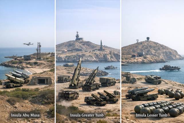
Not all the islands, however, serve the same function. Qeshm is probably the most important pivot from an operational and logistical standpoint. It is large, has infrastructure, possesses strategic depth, and can accommodate not only sensors and batteries but also survival and continuity facilities. Abu Musa, Greater Tunb and Lesser Tunb serve a more advanced and tactical purpose. They are closer to maritime routes, more exposed, but precisely for that reason are ideal for close-range surveillance, asserting control and supporting IRGC forces. Furthermore, their disputed status further enhances their strategic significance. Reuters noted that these three islands have been controlled by Iran since 1971, but are claimed by the United Arab Emirates. Consequently, their militarisation signifies not only the strengthening of the maritime blockade, but also the reaffirmation of a contested sovereignty. Kharg, however, follows a different logic. It is less important for the geometric control of the strait, but crucial for Iranian oil exports and the state’s economic resilience. AP has emphasised that Kharg is vital to Iran’s economy, which means that the Iranian island system can be understood in terms of two circles: a circle of maritime interdiction around Hormuz and a circle of economic support for the state, exemplified by Kharg.
A full understanding of the role of the islands is impossible without clarifying the difference between the IRGC Navy and the regular Iranian navy, the IRIN. Herein lies one of the keys to Iranian maritime doctrine. The Middle East Institute clearly shows that the IRGC Navy dominates the Persian Gulf and the Strait of Hormuz, whilst the IRIN is more oriented towards the Gulf of Oman, the Arabian Sea and a broader naval presence. This division is not a mere bureaucratic separation, but a profound doctrinal distinction. The IRGC Navy is designed for the narrow, congested and highly politicised environment of the Gulf and Hormuz. It capitalises on mobility, surprise, swarm tactics, close-in interdiction, and the use of fast boats, mines, drones and missiles in a space where the advantage lies in the density of the threat, not in the tonnage of the vessel. Islands are the ideal terrain for this type of doctrine. They provide outposts, resurgence points, local logistical support and operational control nodes.
In contrast, the IRIN represents the more conventional dimension of Iranian naval power. Its role is less about the precise control of the strait’s entrance and more about maintaining an extensive naval presence, linking up with maritime areas outside the Gulf, and ensuring the continuity of the Iranian state’s naval representation. In other words, whilst the IRGC Navy is the primary instrument of interdiction and immediate pressure, the IRIN is the component that provides strategic depth, continuity and a link to the wider maritime space. This duality produces a major strategic effect: Iran does not have to choose between asymmetric naval warfare and conventional naval presence, because it combines them institutionally. The islands are thus the points where these two logics meet: they are ‘ ’ utilised operationally primarily by the IRGC, but integrated into a broader naval framework also supported by the IRIN.
This duality also explains why the defence of the islands is so important to Iran. They are not merely locations for the deployment of weaponry, but points of contact between doctrine, institutions and territory. The IRGC transforms them into bastions of interdiction, surveillance and close-in maritime coercion. The IRIN links them to the depth of the general naval apparatus and to the continuity of the state’s naval presence. In the event of a conflict, their defence would likely operate in concentric circles: local defence, proximity defence, protection of critical infrastructure and support from the mainland. This means that the islands are simultaneously the front line and nodes of a much broader strategic network.
The political and legal dimension is equally important. Abu Musa, Greater Tunb and Lesser Tunb are not merely tactical strongholds, but also symbols of the sovereignty claimed by Iran. Reuters reported in 2024 that Tehran reacted vehemently to external references to a peaceful resolution of the dispute over these islands. This shows that, for Iran, they are non-negotiable not only in military terms, but also in terms of identity and diplomacy. Their militarisation is also an assertion of strategic prestige and a rejection of regional or international pressure. This symbolic dimension further amplifies their military value: they are defended not only for what they enable operationally, but also for what they represent politically.
The conclusion is that the Iranian islands surrounding the Strait of Hormuz constitute a system of geographical militarisation. They provide surveillance, support firepower, protect asymmetric mobility, complicate neutralisation, reduce reaction times, support a de facto blockade through deterrence, and reinforce the sovereignty claimed by Tehran. They do not give Iran absolute control over the sea in the classical sense of maritime power, but they do offer something which, in the context of Hormuz, may be almost as valuable: the ability to make the maritime order dependent, even if only temporarily, on its own political and military calculations. In an area through which a critical portion of the world’s energy passes, this represents a form of strategic power of the highest order. In this sense, the islands are not the periphery of Iran’s defensive system. They are one of its cornerstones.
MARITIME SECURITY FORUM