The problem of Arabat and Genichesk– Autor: Dr. Sorin LEARSCHI
The occupation “administration” of the Herson region has begun construction of a new town on the Arabat limbo near Genichesk. According to Flot 2017, the so-called “governor” of the region, Vladimir Saldo, told Kremlin journalists about this. As specified, the settlement is to be built directly on the sandy limbo. Currently, design and preparation work is underway. The new town will be designed for 30,000 inhabitants. At the same time, the occupants hope to create a “modern” infrastructure in the settlement. The Russians want to set up “government” institutions and “other territorial bodies” there. Russia also wants to build a highway linking the occupied Ukrainian regions to the Taurida highway in Crimea. The road is planned to pass through Dzhankoy, Chongar, Genichesk, Melitopol, Mariupol, Berdyansk and on to the Russian Rostov-on-Don. It will be a circular motorway. Design work and surveys are currently underway.
Arabat
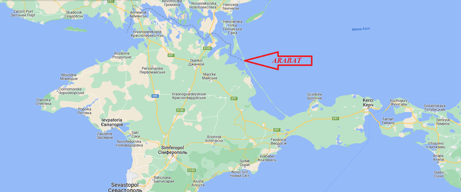
Arabat is a narrow, waterless sandy strip separating Sivash from the Sea of Azov, literally a Crimean sandbar to the Sea of Azov. Not coincidentally, in the 1920s, Red Army divisions marched along it to the peninsula, and during World War II, both the Germans and Russians used it during the offensive. The length is about 120 km. The peninsula has always been considered, by Russia, part of Crimea, especially in the Azov region, but is now (legally) administratively divided into two almost equal parts between Ukraine and Russia. Because of this sand tongue in northeastern Crimea, it is literally in a sort of semi-embracing of independent Ukraine. Exactly half of its length, the northern part and almost the entire central part (Strelkovsky and Schastlivtsevsky districts) – legally belong to Ukraine. A direct consequence of the division, language has become a current strategic vulnerability of Crimea. In the event of various types of conflict, it will remain a serious problem. The beginning was a long time ago, exactly one year after the transfer of Crimea from the RSFSR to the Ukrainian SSR – in March 1955. Before that, the whole territory was, quite logically, part of the administrative structure of the peninsula. What happens if the region returns to Russia? Initially, before the war began, Ukraine was offered the opportunity to secure vulnerable borders near the far east coast of Crimea. There are various texts in several books and magazines. Therefore, we will simply quote here the key lines from the “Decree of the Presidium of the Supreme Soviet of the Ukrainian SSR” on the transfer of the Strelkovsky and Schastlivtsevsky village councils from the Crimean region to the Kherson region”.
A very strange term was used for such territorial changes – “list”.
What is more characteristic: in November 1952, the Presidium of the Supreme Soviet of the Ukrainian SSR, on the “recommendation” of the Presidium of the Central Committee of the CPSU, prepared a draft resolution on the transfer of the city and port of Genichesk to the Crimean region of the RSFSR. At that time, they understood its connection to the peninsula and made sure it was in Crimea. In Moscow it was quite objectively believed that Genichesk was historically centred on economic and cultural links with Crimea and not the Kherson region. In addition, Crimea had to have its own port on the Sea of Azov, otherwise the entire eastern peninsula would be doomed to long-term underdevelopment. But … Stalin soon died, the issue was hidden, and Genichesk remained and remains a part of the Kherson region of Ukraine. The city and its surroundings – fertile and very beautiful lands are separated by a narrow strait – Arabat. The length of this strait is only about 4 km and the width does not exceed 135 m. The need for the nomination of Genichesk in Crimea is even historically confirmed. For example, the fact that Genichesk is designated as part of the Crimea on the “Map of the Crimean Khanate and the Waters Washing it”, drawn up in 1562 by the British Anthony Jenkinson. In addition, Genichesk – through its transfer to the Crimean region of the RSFSR – was planned to be renamed Ust-Azovsk. Whereas in translation from Turkish and Nogai, the former name means “thin water” and “thin water (…)” respectively: in both versions, a fortress or port is understood in a narrow strait between Sivash and the Sea of Azov. But the Ukrainian authorities have managed to ignore the Stalinist project to unite Genichesk with Crimea. Moreover, as early as the second half of 1953, the Crimean region began to prepare for subordination to the Ukrainian SSR. That is why Ukrainian Crimea did not “need” Ust-Azovsk … This 1590 map was included in the first global geographical atlas “The Spectacle of the Earthly World” by the Flemish cartographer Abraham Ortelius. The same was indicated in 1687 by the map of the Crimean Khanate by the German geographer Yokhim Sandrart. As far as Arabat Spit is concerned, from 15 March to December 2014 inclusive – part of this arrow (northern and 70% central), which is not part of Crimea, was controlled by Russia. Which, of course, strengthened Crimean security. In a broader context, the position of “Genichesk and the whole of Crimea” would allow the re-establishment of a legally legitimate and natural geographical border in the northeast of Russian Crimea. And within this border there has always existed – both in the Crimean Khanate and before its creation – exactly the entire Arabat arrow. But it didn’t happen: it seems that under external pressure, since January 2015, the Russian-Ukrainian border in the same isthmus has been restored between the “brotherly” republics since 3 March 1955. Past and people Genichesk historically, since the time of the Crimean Khanate (13th-18th centuries), is closely linked to the Crimean economy. For centuries, the port of Genichesky accounted for about a third of Crimean foreign trade. And then, and later, Genichesk, due to its location, was considered an outpost blocking the Sivash of Crimea and northeastern Crimea from external aggression. Such a role of Genichesk in the Soviet period was manifested, for example, in the fact that more than a quarter of the cargo traffic between Crimea and the Ukrainian SSR in the 1930s and in 1946-1955 was carried through Genichesk. It is also characteristic that Genichesk, from the 1960s to the present day, has been supplied with gas from northern Crimea. It is surprising that in 2016-2017. due to the “gas famine” in the Kherson region of Ukraine, the supply of this gas to Genichesk increased by almost half. Informal trade between Ukraine and Crimea continued, despite barriers, bans and challenges. And these deliveries were mainly through Genichesk. In the second half of the 19th century, the Transkrym postal route was built on the Arabat Spit – from Feodosia to Genichesk, with five postal stations along the route. And shortly before the beginning of the 20th century, a single-track railway was built from Arabat Spit to Genichesk, 45 km long. It is worth proving that this was done to strengthen the peninsula’s internal and external economic links. But later, after about a hundred years, this road was abandoned by the Ukrainian SSR authorities, and in the late 1990s of the last century, they dismantled it. Proposals by Ukrainian experts to extend this artery along the Arabat Spit to the Vladislavovka-Kerch railway were rejected by the authorities for the same reason. And for the same purpose: the northern part of Genichesk was transferred from Crimea to the Kherson region on 3 March 1955 …
Maritime Security Forum